Measurements
taken by satellites indicate that the eastern flank of Mount Etna is slowly
sliding into the Ionian Sea. However, these measurements only take into account
the portion of the volcano that is above the water surface, as the satellite
signals cannot penetrate the water and measure the movements and deformations
of the soil underwater.
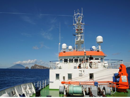
So
scientists in Kiel have set out last Thursday on the research vessel Poseidon
to set up a new survey network off the Sicilian coast so as to take
measurements for the submerged portion of the volcano.
With
seven eruptions since the start of the millennium, Mount Etna in Sicily is the
most active volcano in Europe. Its lava flows have repeatedly destroyed houses,
roads and the other infrastructure in the vicinity. The town of Catania,
located at the foot of Mount Etna, is an important industrial centre in
southern Italy with about a million inhabitants. Not surprisingly, the
scientists and authorities there monitor the volcano's status very closely.
There are stations that use satellite data to accurately detect the movement of
the mountain.
And
now, the monitoring will be extended with the help of the scientists from
GEOMAR. On board Poseidon are monitoring systems similar to those installed in
the seabed in earthquake-prone regions like Istanbul and off northern Chile.
Project manager Dr Morelia Urlaub (from GEOMAR Helmholtz Centre for Ocean
Research Kiel) explained that their systems made use of a sound-based variant which
opens up new avenues for research into natural hazards in the oceans.
During
this expedition, the researchers will install six geodesic stations at depths
of 700 metres below the water surface off the eastern coast of Sicily.
Using
sound, the geodesic stations would measure the distance from one another to a
fraction of a centimetre. Three ground-inclinometers and six classic ocean
bottom seismometers, which can detect even the smallest vibrations underground,
complete the monitoring network.
Just
a slight movement of the volcano's flanks may signal an impending eruption, and
underwater landslides can trigger a tsunami. This would spell danger for the
entire region, particularly in the densely populated coasts in the
Mediterranean where millions of tourists congregate during the summer months.
"The
idea of a tsunami in the Mediterranean is not conjured out of thin air. An
earthquake in the Strait of Messina in 1908 triggered a tsunami, killing about
two thousand people, "said Professor Krastel in German.
Marine
geodesy, the sound-based surveying of the Earth underwater, is still a very new
method used in the research of natural hazards. Nevertheless, Dr Urlaub
expressed hope that knowledge about the movements of Etna could subsequently be
expanded.
 Mares
Mares 29th March 2016
 Mount Etna