Enhancing the analysis of climatic changes in the Arctic

by   Profile Mares   When 16th June 2016
Aufnahme von der ersten Tiefsee-Testfahrt des AWI-Tiefseeroboters TRAMPER. 
Forscher und Ingenieure des Alfred-Wegener-Institutes (AWI) hattben während der aktuellen Forschungsreise des Forschungsschiffes Sonne (So 242-2) erste erfolgreiche Tiefsee-Fahrten mit dem autonom agierenden AWI-Unterwasserroboter Tramper durchgeführt. Die Testfahrten des Kettenfahrzeuges erfolgten in einer Tiefe von 4150 Metern in einem Geabiet des tropischen südöstlichen Pazifiks, circa 850 km vor der Küste Perus. Tramper wird von den AWI-Tiefseeforschern im Rahmen der Helmholtz-Allianz Robotische Exploration unter Extrembedingungen (ROBEX) entwickelt und soll künftig im Projekt FRAM als eigenständig agierende robotische Plattform für Sauerstoffmessungen in der arktischen Tiefsee dienen – dort insbesondere am AWI-Tiefseeobservatorium HAUSGARTEN.

English:
Image from the first endurance test for AWI deep sea robot TRAMPER
 
During an expedition on board the research vessel Sonne (So 242-2), researchers and engineers from the Alfred Wegener Institute (AWI) successfully used the autonomous AWI robot, Tramper, for the first time on a deep-sea mission. The continuous-track vehicle’s first demo missions took place at a depth of about 4150 metres in an area of the subtropical Southeast Pacific around 850 km off the coast of Peru. Tramper was developed by AWI deep-sea researchers as part of the Helmholtz Alliance Robotic Exploration of Extreme Conditions (ROBEX) and will be used in future in the FRAM project as an autonomous robotic platform for oxygen measurements in the Arctic deep-sea  - particularly at the AWI deep-sea observatory HAUSGARTEN there.
AWI's ROV Tramper on the seabed during a test with the research vessel Sonne. (c) ROV-Team, GEOMAR
Das deutsche Polarforschungsschiff Polarstern vor der Küste Spitzbergens. 

The German polar research vessel Polarstern in front of the mountains of Spitsbergens (Svalbard). 

Fotos von der Polarstern-Expedition ARK-XXVII-1 im Sommer 2012 (14. Juni - 15. Juli 2012, Bremerhaven-Longyearbyen); 
Forschungsschwerpunkte: 

Ozeanografie: Projekt ACOBAR - Messung von Salzgehalt, Sauerstoff und Wassertemperatur an 80 Stationen entlang eines Schnittes bei 78°50' N;

Biologie: Netzfänge und Sedimentprobennahme an den Stationen; Amphipoden-Untersuchungen (PECABO); Beobachtungen von Seevögeln und Meeressäugern; 

engl: 

Photo taken by Sebastian Menze during the Polarstern expedition ARK-XXVII-1 in summer 2012 into the Fram Strait, duration: 14th June - 15th July 2012
The German research vessel Polarstern off the coast of Spitsbergen. (c) Sebastian Menze
Projekt ROBEX, Helmholtz-Allianz. Mitglieder der Helmholtz-Allianz ROBEX testen das Unterwasserfahrzeug AWI-Tramper im Becken des DFKI Bremen. In ROBEX arbeiten Tiefsee- und Weltraumforscher zusammen, um Technologien weiterzuentwickeln. So wollen Wissenschaftler des Alfred-Wegener-Instituts zukünftig die Tiefsee in der Framstraße zwischen Spitzbergen und Grönland mit autonomen Unterwasserfahrzeugen wie dem Tramper erforschen.
The Helmholtz Alliance ROBEX testing the underwater vehicle AUV Tramper in a test tank. (c) Lars Grübner
de: Bergung des autonomen Unterwasserfahrzeuges (AUV) mit dem Helikopter aus dem Treibeis nach dem weltweit ersten Untereis-Tauchgang während der Polarstern-Expedition ARK-XXV/2.

en: Recovery of the Autonome Underwatervehicle (AUV) with the helicopter after the first under-ice mission during the Polarstern-Expedition ARK-XXV/2.
Recovery of the AUV PAUL by helicopter from the drift ice after a dive under the ice. (c) Mascha Wurst
Das AUV Paul fährt vorprogrammierte Kurse bis in Tiefen von 3000 m selbständig ab.
The AUV PAUL can travel on preprogrammed courses to depths of 3,000 metres independently. (c) Alfred Wegener Institute

Scientists head northwards with new autonomous instruments

On 13 June 2016, a team of scientists set off to Spitsbergen on a
mission to use some newly developed equipment in the Arctic Ocean,
geared towards analysing the climatic changes in the Arctic and their
impact on the fauna in the future with greater temporal and spatial
resolution.
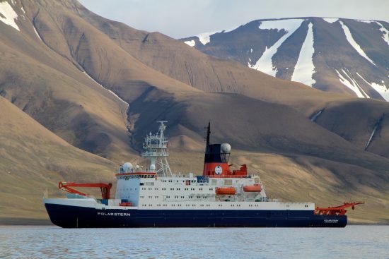
The scientists, from the Alfred Wegener Institute, the Helmholtz Centre
for Polar and Marine Research (AWI), are travelling on board the German
research vessel Polarstern.

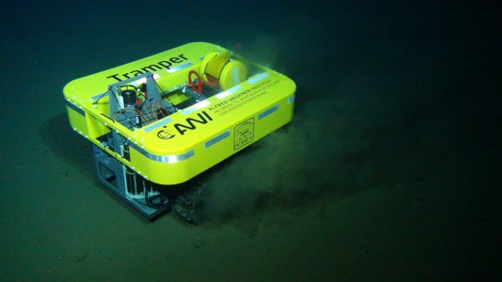
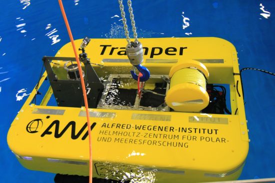
The new equipment, comprising autonomous instruments on the seabed, in
the water column and in the air, will complement the long-term
measurements of the deep-sea research group. For the first time, an
Autonomous Underwater Vehicle (AUV) called Tramper will be deployed on
the Arctic seabed for a year.

"The newly developed device is to measure oxygen along the depth
gradients on a weekly basis. In this way, we want to quantify how the
sediment-dwelling marine organisms remineralise the biomass on the sea
floor,
" said Dr Thomas Soltwedel, deep-sea ecologist at AWI and the
expedition's chief scientist.

With this mission, the scientists want to find out two main things: how
climate-induced changes in the productivity of algae on the water
surface, in and under the sea ice are temporally coupled to the export
of nutrients in the deep sea, and how deep-sea organisms react to the
presumably strong variability in food availability.

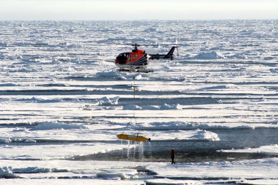
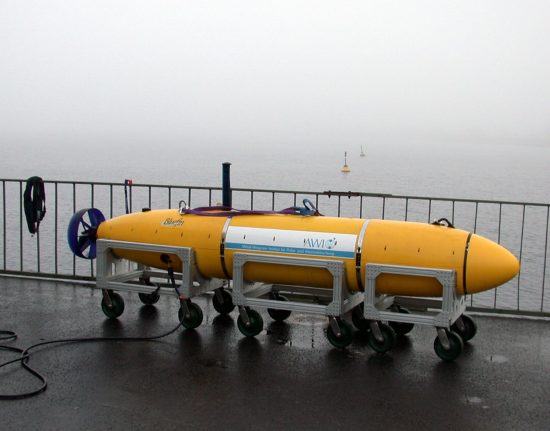
Another AUV, called PAUL, will float on a pre-programmed course through
the water column, collecting water samples and detecting a range of
environmental factors. PAUL has been equipped ala a small laboratory,
and will measure water temperature, salinity, concentrations of
nitrate, chlorophyll and oxygen, as well as a range of organic
substances and the intensity of photosynthetically active radiation.
PAUL can also measure the physical properties along the melt-water
border on the edge of the ice of the Arctic Ocean using a built-in
acoustic Doppler current profiler (ADCP).

Autonomous flying devices called Unmanned Aerial Vehicles (UAVs) will
be used to understand the ice conditions above PAUL. They will measure
the thickness of the snow cover and the ice coverage. The scientists
can measure the extent to which sunlight (as energy) reaches the ocean
under the ice. One of the UAVs will place GPS transmitters on the sea
ice to record the ice drift. The data will be used to programme the
AUVs' route.

Further Information: www.awi.de

Written by
Profile Mares
Date
When 16th June 2016
Share
Share on FacebookShare on Google+Tweet about this on TwitterPin on Pinterest
COMMENTS
The post has no comments.

Leave a Reply

Your email address will not be published. Required fields are marked *

Also by Mares