

New age imaging system brings 3-D perspective to underwater sites
A revolutionary new multi-function, underwater imaging system has been developed by the Advanced Imaging and Visualization Laboratory (AIVL) at the Woods Hole Oceanographic Institution (WHOI), working together with Marine Imaging Technologies.
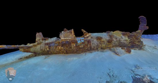
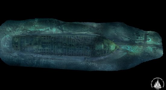
This new technique can generate ultra-high definition television (UHDTV) video, 2-D mosaic imaging and 3-D optical models of seafloor objects and environments. Currently, it is being field-tested on several shipwreck sites in the United States and Europe.
The WHOI is a private, non-profit organization on Cape Cod, Massachusetts, dedicated to marine research, engineering and higher education. Established in 1930 on a recommendation from the National Academy of Sciences, its primary mission is to understand the ocean and its interaction with the Earth as a whole. As a result of these activities, WHOI is also trying to communicate a basic understanding of the ocean's role in the changing global environment.
New cutting-edge technology
The cutting-edge technology will enable rapid production of 3-D optical volumetric models of the seafloor - images that scientists can spin to view from all sides, and zoom in on to visually explore around and inside objects or ocean environments. These models are helping to transform the way scientists examine study areas, be it coral reefs, marine protected areas, maritime heritage sites or hazardous material sites.
Currently, 3-D models require months of processing back in the lab. In contrast, the new imaging system can make models in a shorter period of time—even during expeditions at sea.
“This is really exciting because the deep sea is a realm with very limited access,” said Tim Shank, a deep-sea biologist at WHOI. “Even when scientists are able to dive in a submersible, […] we typically have just a few hours on the seafloor per day. Due to the great pressures that increase with ocean depth, it's impossible to step out of the sub and experience the terrain and its thriving ecosystems in three dimensions.”
“These high-resolution 3-D models will allow us to visually walk through the seafloor landscape among the biological communities that live there, much like a wildlife biologist would walk through a rainforest,” Shank added.
After a research expedition at sea, scientists typically spend weeks reviewing still images and video captured by underwater vehicles or other instruments. William Lange, director of AIVL, said that the new models will help streamline the process of interpreting the data.
“We can learn things from the Titanic site”
AIVL has begun conversion of the lab's 2-D optical mosaics of the Titanic site, which were created in 2011. The lab will incorporate newly-acquired imagery from the legendary wreck site more than a century after the luxury liner sank on its maiden voyage in 1912.
“We can learn things from the Titanic site about what happens to ships in the deep sea over time,” Lange said. “There are very few places on the bottom of the ocean that we have a 25-year history of what’s happened there. And these 3-D optical models will allow people to see it as they never have before.”
In addition to benefitting science and research, Lange added that the technique is a generic tool with many possible applications in everything from education, film production and industry.
See this video for more information
 Herbert
 1st August 2017